Maps are an essential tool for understanding the world around us, and teaching map skills to children is crucial. With the rise of technology, it’s easy for kids to overlook the importance of map reading. However, learning how to read maps is a valuable skill that can help them improve their spatial awareness and understand the world around them. In this article, we’ll explore the benefits of map skills, different types of maps for kids, and discounted map resources for teachers. With these resources, teachers can help their students develop a love for geography and map reading that will last a lifetime.
Contents
- Why Teach Map Skills?
- Types of Maps for Kids
- Discounted Map Resources for Teachers
- Conclusion
-
Frequently Asked Questions
- What age should kids start learning map skills?
- What are the benefits of teaching map skills to kids?
- How can map skills be integrated into the curriculum?
- What are some different types of maps for kids?
- What is a topographical map?
- What are some online resources for teaching map skills?
- Are there any discounts available for teachers on map resources?
- What are some DIY map-making projects for kids?
- Why is it important for kids to learn how to read maps?
- How can parents reinforce map skills at home?
- References
Why Teach Map Skills?

Learning map skills is an essential part of a child’s education. Map skills help children understand spatial awareness and learn more about the world around them. By teaching kids how to understand maps, they can learn to make sense of a map key, map symbols, and directions. It can help children develop critical thinking and problem-solving skills. Integrating map skills into the curriculum can help children learn about geography, history, and other subjects. While there are many free resources available online to teach map skills, educators can also use educational insights to create engaging and interactive lessons.
Benefits of Map Skills
Teaching map skills to kids is important because it develops their spatial awareness and helps them understand the world around them. Learning how to interpret maps and use them to navigate is a fundamental life skill that can benefit kids in numerous ways. Here are some of the benefits of map skills:
| Improved spatial reasoning: | Map skills help kids develop their spatial reasoning abilities, which are important for tasks such as solving puzzles, understanding graphs and charts, and visualizing objects in 3D. |
| Enhanced critical thinking: | Using maps requires critical thinking skills, such as problem-solving, decision-making, and analysis. These skills are valuable in many areas of life, including academics, work, and personal relationships. |
| Expanded knowledge: | Learning about maps can expose kids to new information about their community, country, and the world. It can also help them understand geography, history, and other subjects in greater depth. |
| Increased independence: | Knowing how to use a map can help kids become more independent and self-reliant. They can use maps to navigate their neighborhoods and cities, plan trips, and explore new places. |
Incorporating map skills into the curriculum can help kids develop these valuable abilities. By using different types of maps, such as world maps, country maps, state maps, city maps, and topographical maps, kids can learn about different places and develop their map-reading skills. Teachers can also take advantage of discounted map resources for teachers, such as online resources, discounts for teachers, and DIY map-making projects. By teaching map skills to kids, we can help them become more knowledgeable, independent, and critical thinkers.
Integrating Map Skills into Curriculum
Integrating map skills into curriculum can benefit students in a variety of subjects. For example, social studies lessons on geography and history can be enhanced by using maps to help students visualize the location and movement of people, events, and ideas. Science lessons can also utilize maps to help students understand concepts such as land formations, weather patterns, and environmental changes. Additionally, language arts lessons can incorporate maps by having students create maps to accompany stories or poems they have written.
One way to integrate map skills into curriculum is by creating interdisciplinary lessons that combine different subjects. For example, students could read a historical fiction novel set in a specific location, then research and create a map of that location and its historical significance. This activity would involve reading, writing, social studies, and geography skills.
Another way to incorporate map skills is to use technology such as Google Maps or other online mapping tools. Students can use these tools to explore different locations, identify landmarks, and create their own virtual tours of places they have researched.
Teachers can use hands-on activities to teach map skills, such as having students create their own maps. This can be done using materials such as paper, markers, and other craft supplies. Students can create maps of their school, neighborhood, or town, and include important landmarks, streets, and other features.
By integrating map skills into curriculum, teachers can help students develop spatial awareness and a deeper understanding of the world around them. These skills can benefit students in a variety of subjects and help prepare them for future academic and professional success.
Types of Maps for Kids

Maps are a great tool for teaching kids about geography and spatial awareness. There are many different types of maps that can be used to teach children about the world around them. World maps are a great way to introduce kids to the continents and oceans. Country maps can help children learn about different cultures and languages. State maps can teach children about their own state and its history. City maps can help kids navigate their town or city. Finally, topographical maps can be used to teach children about elevation and landforms. By using a variety of maps, teachers can help children learn about the world in a fun and engaging way.
World Maps
World maps are one of the most popular types of maps for kids. They show the entire world and all of its continents and oceans. World maps are a great way to introduce kids to geography and help them understand the size and shape of the world. They can also be used to teach kids about different countries and their cultures. Some fun activities for kids to do with world maps include finding and labeling different countries, identifying the world’s major oceans and continents, and tracking the path of a family vacation. You can find printable world maps online, or invest in a large, colorful world map poster to hang in your classroom or at home. For more interactive learning, consider using online resources like National Geographic Kids, which has games and quizzes to help kids learn about the world around them.
Country Maps
Country maps are a great way to introduce children to geography and the concept of countries. These maps show the boundaries of different countries, as well as their capital cities and major landmarks. Kids can learn about different cultures, languages, and traditions by studying country maps. Teachers can use country maps to help kids develop social studies skills, including understanding different cultures and societies. Additionally, ABCmouse offers interactive country map activities for kids, making learning about different countries fun and engaging. With the help of country maps, kids can develop a better understanding of the world around them and become more knowledgeable global citizens.
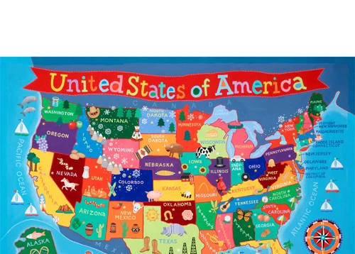
State Maps
State maps are a great way to teach geography and history to children. These maps show the boundaries of each state and often include important landmarks and cities. One fun activity for students is to have them label each state with its capital city. This activity can help students learn the names and locations of state capitals, which is important knowledge for history and social studies classes. Another activity is to have students color in each state with a different color, which can help them visualize the different regions of the United States. In addition to learning about geography and history, state maps can also be used to teach math skills. For example, students can compare the sizes of different states using a scale. This activity can help students learn about ratios and proportions. There are many online resources available for teaching with state maps, such as ABCmouse.com and Quizlet. Teachers can also find discounted map resources through websites like ABCmouse.com and Grammarly. State maps are a valuable resource for teaching a variety of subjects and skills to children.
City Maps
City maps are an excellent tool for teaching young learners about their local community and how to navigate it. These maps provide a detailed view of streets, landmarks, parks, and other important locations. They can be used to teach children about directions, distance, and scale. City maps are also great for teaching children about the different types of transportation they can use to get around.
Here are some key features of city maps:
- Street names and addresses
- Landmarks such as parks, schools, and hospitals
- Transportation routes such as bus stops and train stations
- Icons indicating important locations such as museums, restaurants, and shopping centers
City maps can be used in a variety of ways in the classroom. For example, students can use city maps to plan a walking tour of their neighborhood or to locate different types of businesses in their community. They can also use city maps to practice their map-reading skills by following a set of directions to get from one location to another.
Discounted Map Resources for Teachers:
Teachers can find a variety of discounted map resources online to use in their classrooms. Some great options include:
- ABCmouse.com – offers a variety of interactive map activities for young learners
- Grammarly – provides free resources for teaching grammar and writing, including map-related activities
- Adventure Academy – offers a virtual world where students can explore different types of maps and learn about geography
- Space board games – a fun way to learn about maps and geography with a space twist
Topographical Maps
Topographical maps are an excellent way for kids to learn about the physical features of an area. These maps use contour lines to show changes in elevation, helping kids understand the different heights of mountains, valleys, and other landforms. Topographical maps are often used by hikers and outdoor enthusiasts to plan their routes and explore new areas. They are also useful for scientific research and environmental studies.
Benefits of Topographical Maps for Kids:
- Enhances spatial awareness and understanding of landforms
- Encourages critical thinking and problem-solving skills
- Helps develop navigation and orienteering skills
- Provides a basis for scientific and environmental studies
Integrating Topographical Maps into Curriculum:
Teachers can incorporate topographical maps into their curriculum in a variety of ways. For example, students could use topographical maps to study the geography of a particular region or to plan a hiking trip. They could also use topographical maps to learn about the impact of natural disasters, such as floods and landslides.
Types of Topographical Maps:
There are several types of topographical maps that kids can explore, including:
- Contour Maps – show changes in elevation using contour lines
- Shaded Relief Maps – use shading to show changes in elevation
- Physical Maps – show the physical features of an area, such as mountains, rivers, and lakes
Topographical maps are a valuable tool for teaching kids about the physical features of the world around them. By incorporating these maps into their curriculum, teachers can help students develop important skills and a deeper understanding of geography and the environment.
Discounted Map Resources for Teachers
Discounted map resources are available for teachers to help them make learning about maps fun for students. There are several online resources that offer free and low-cost map resources for teachers. Teachers can also take advantage of discounts for teachers on map-making software and other materials. Additionally, DIY map-making projects can be an engaging way for students to learn about maps while also encouraging creativity and critical thinking skills. With these discounted map resources available, teachers can help students gain important map skills while keeping their budget in mind.
Online Resources
There are many online resources available to help teach map skills to kids. These resources include interactive games, printable worksheets, and educational videos. Here are some popular online resources:
| Website | Description |
|---|---|
| National Geographic Kids | Offers interactive games and activities that teach kids about maps and geography. |
| Google Earth | Allows kids to explore the world through satellite imagery and maps. |
| Maps101 | Provides lesson plans, activities, and resources for teaching map skills. |
| ESRI GIS for Schools | Offers free mapping software and resources for K-12 students and teachers. |
| Sheppard Software | Provides a variety of online geography games and quizzes. |
These online resources are a great way to supplement classroom learning and engage kids in interactive and fun ways. Additionally, many of these resources are free, making them accessible to teachers and families on a budget.
Discounts for Teachers
Teachers are always looking for ways to bring new and exciting resources into their classrooms while staying within budget. Many map companies offer discounts and special pricing for teachers to help make this possible. For example, National Geographic offers a 30% discount on their maps and atlases to educators. They even have a special section on their website dedicated to teachers where they can find lesson plans, activities, and other resources. Another great resource for discounted maps is Maps.com. They offer a 20% discount to teachers and have a wide variety of maps for all grade levels. Teachers can also check with their local map stores or office supply stores to see if they offer any discounts or special pricing for educators. By taking advantage of these discounts, teachers can provide their students with engaging and informative map resources without breaking the bank.
DIY Map-Making Projects
For teachers looking to engage their students in a fun and hands-on way, DIY map-making projects are a great option. These projects not only teach map-making skills, but also allow students to flex their creativity and imagination. Here are some simple and affordable ideas to get started:
| Map Collage: | Have students collect old magazines, newspapers, and other printed materials. Instruct them to cut out pictures of different locations and landmarks to create a map collage. They can then label the different areas and discuss the significance of each location. |
| 3D Map: | Using salt dough or clay, students can create a 3D map of a particular area. They can sculpt mountains, hills, rivers, and other geographical features, then paint and label the different areas. This project is a great way to teach topographical map skills. |
| Treasure Map: | Students can design their own treasure maps, complete with a legend, compass rose, and hidden treasure. This project is a great way to teach directionality and map symbols. |
| Map Quest: | Using a neighborhood or school campus as a guide, students can create their own scavenger hunt or map quest. They can design a map with clues and landmarks, then challenge their classmates to follow the map to complete the quest. |
These DIY map-making projects are just a few examples of the many ways teachers can incorporate map skills into their curriculum. By making maps fun and engaging, students are more likely to retain the information and develop a lifelong love of geography.
Conclusion
Teaching map skills to kids is crucial for their spatial awareness and understanding of the world around them. By integrating map skills into the curriculum, children can learn about geography, history, and culture. There are various types of maps available for kids, including world maps, country maps, state maps, city maps, and topographical maps. Teachers can find discounted resources for maps online and even create DIY map-making projects for their students. With these tools, teachers can make map skills fun and engaging for kids of all ages. So, let’s help children become proficient in map reading and encourage them to explore the world beyond their own backyard.
Frequently Asked Questions
What age should kids start learning map skills?
Even young children can begin learning basic map skills, such as understanding a map key and symbols. However, more advanced map skills can be taught to children in upper elementary grades.
What are the benefits of teaching map skills to kids?
Teaching map skills to kids can help them develop spatial awareness, improve their understanding of geography, and enhance their problem-solving skills.
How can map skills be integrated into the curriculum?
Map skills can be integrated into various subjects, such as social studies, science, and math. For example, students can study different types of maps in social studies, create topographical maps in science, and use maps to calculate distances in math.
What are some different types of maps for kids?
Some different types of maps for kids include world maps, country maps, state maps, city maps, and topographical maps.
What is a topographical map?
A topographical map is a type of map that shows the physical features of an area, such as mountains, rivers, and valleys. These maps use contour lines to show changes in elevation.
What are some online resources for teaching map skills?
There are many online resources available for teaching map skills, such as interactive games, map quizzes, and printable worksheets. Some examples include National Geographic Kids, KidsGeo, and Education.com.
Are there any discounts available for teachers on map resources?
Yes, many map companies offer discounts for teachers on their resources. For example, National Geographic offers a discount to educators on their maps and atlases.
What are some DIY map-making projects for kids?
Some DIY map-making projects for kids include creating a treasure map, making a map of a fictional place, or drawing a map of their neighborhood or school.
Why is it important for kids to learn how to read maps?
Even with the prevalence of GPS technology, it is still important for kids to learn how to read maps. Map reading helps to develop spatial awareness, critical thinking skills, and an understanding of geography and the world around us.
How can parents reinforce map skills at home?
Parents can reinforce map skills at home by encouraging their kids to use maps when traveling, playing map-related games, and using maps in everyday activities, such as finding directions or planning a route.